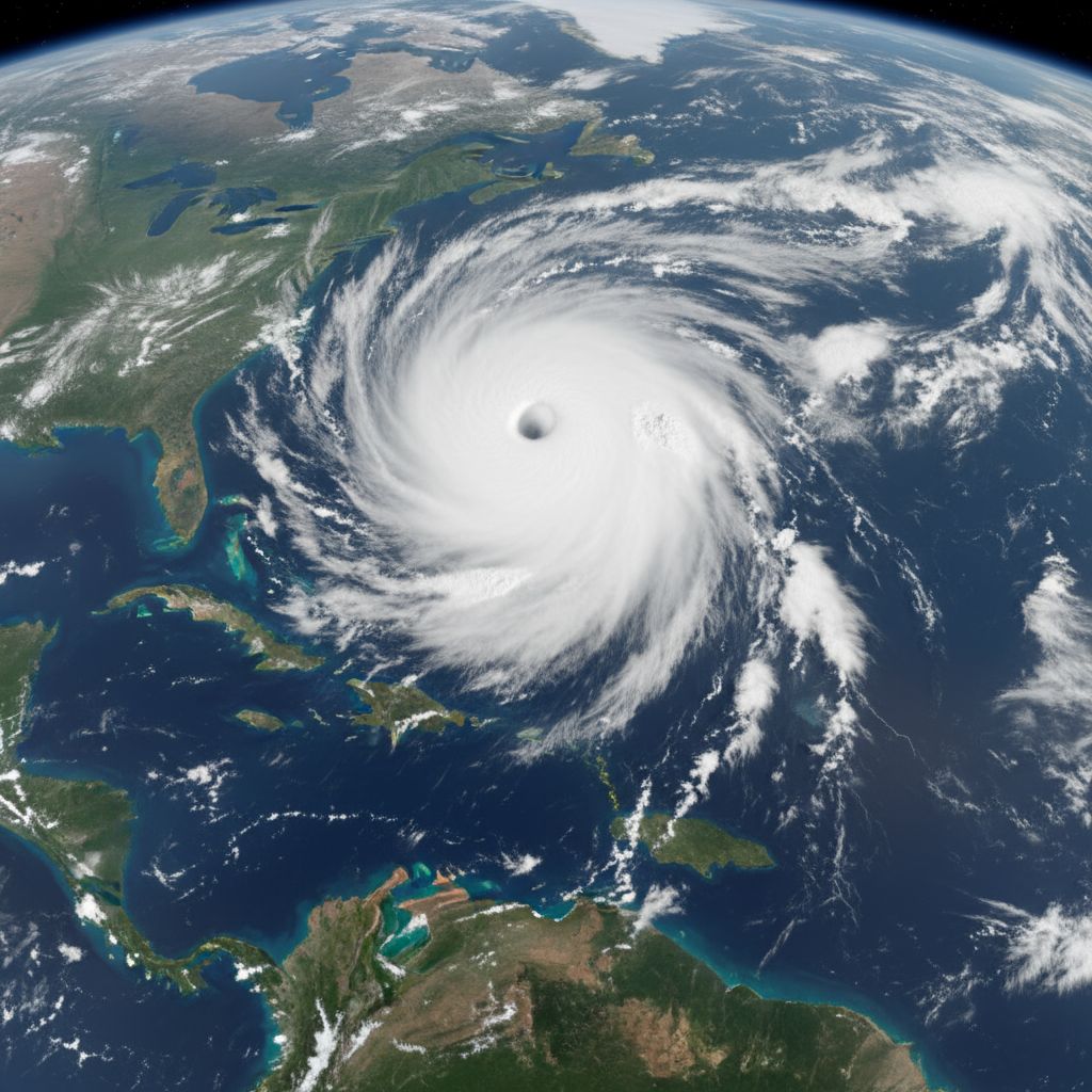
Hurricane Melissa has intensified into a catastrophic Category 5 storm with maximum sustained winds of 160 mph, making it the most powerful hurricane to threaten Jamaica in recorded history. The slow-moving monster storm is currently positioned approximately 130 miles south-southwest of Kingston and is expected to make a devastating direct hit on the Caribbean island early Tuesday morning.
Record-Breaking Intensity Threatens Historic Devastation
The National Hurricane Center confirmed Monday morning that Melissa has reached the highest category on the Saffir-Simpson Hurricane Wind Scale, with a central pressure of 917 millibars - an indicator of the storm's extreme intensity. Air Force Reserve Hurricane Hunter aircraft measured flight-level winds of 175 mph, confirming the storm's catastrophic strength.
This marks a historic moment for the Atlantic Basin, as Melissa joins Hurricane Erin and Hurricane Humberto as the third Category 5 storm of the 2025 season - the most Category 5 hurricanes in a single year since 2005. The storm represents the 44th Category 5 hurricane in the Atlantic Basin since records began in 1924.
Jamaica Faces Unprecedented Threat
Jamaica has never experienced a direct landfall from a Category 4 or 5 hurricane in recorded history, making Melissa's approach particularly alarming. The strongest storm to previously hit the island was Hurricane Gilbert in 1988, which made landfall as a Category 3 storm with 130 mph winds, killing 45 people and causing $700 million in damage.
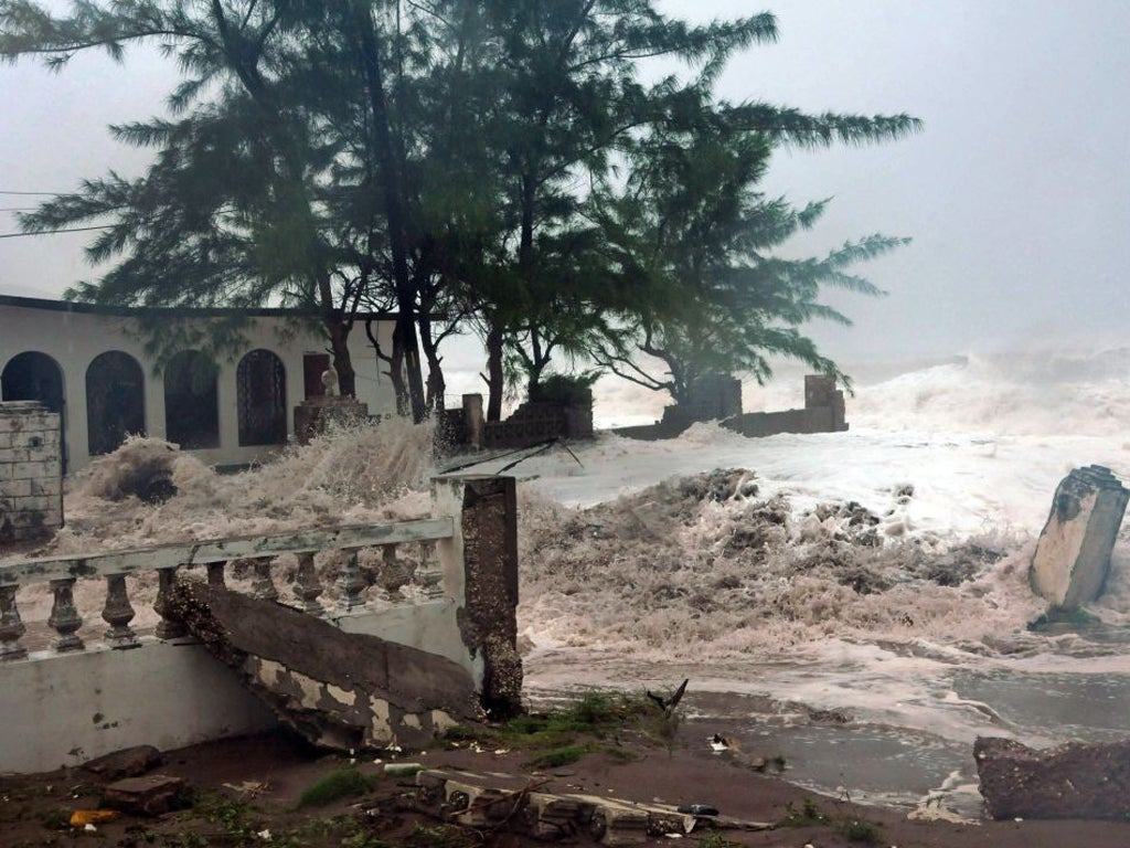
Melissa's projected impact significantly exceeds Gilbert's destructive power, with forecasters warning of "catastrophic and life-threatening flash flooding and numerous landslides" across the island. The storm's painfully slow movement of just 3 mph means Jamaica will endure punishing conditions for an extended period.
Catastrophic Impacts Expected Across Multiple Threats
Devastating Rainfall and Flooding
Melissa is forecast to dump between 15-30 inches of rain across Jamaica, with some eastern regions potentially receiving up to 40 inches. This rainfall amount surpasses the typical annual precipitation for some areas of the country. The mountainous terrain will exacerbate conditions, forcing air masses to rise and produce even more rainfall.
Life-Threatening Storm Surge
A storm surge of 9-13 feet above ground level is expected along Jamaica's southern coast, particularly east of where Melissa's center makes landfall. This surge poses particular danger to Norman Manley International Airport and coastal communities around Kingston.
Destructive Winds
With maximum sustained winds of 160 mph and gusts potentially exceeding 195 mph in mountainous areas, Melissa will likely cause widespread power outages, structural damage, and downed trees across the island. Wind speeds in elevated regions could exceed the storm's core winds by 30%, potentially reaching over 200 mph.
Government Response and Mass Evacuations
Jamaican Prime Minister Andrew Holness has declared the entire island a "threatened area" under the Disaster Risk Management Act, empowering agencies to take all necessary protective measures. The government has implemented mandatory evacuation orders for vulnerable coastal and flood-prone communities, including:
Port Royal in Kingston
Portland Cottage and Rocky Point in Clarendon
Old Harbour Bay in St. Catherine
Several neighborhoods in St. Andrew
Over 881 emergency shelters have been activated across the island, with supplies distributed and emergency personnel on standby. Minister of Local Government Desmond McKenzie issued urgent warnings, stating: "Do not gamble with Melissa. It's not a safe bet".
Regional Impact and Continuing Threat
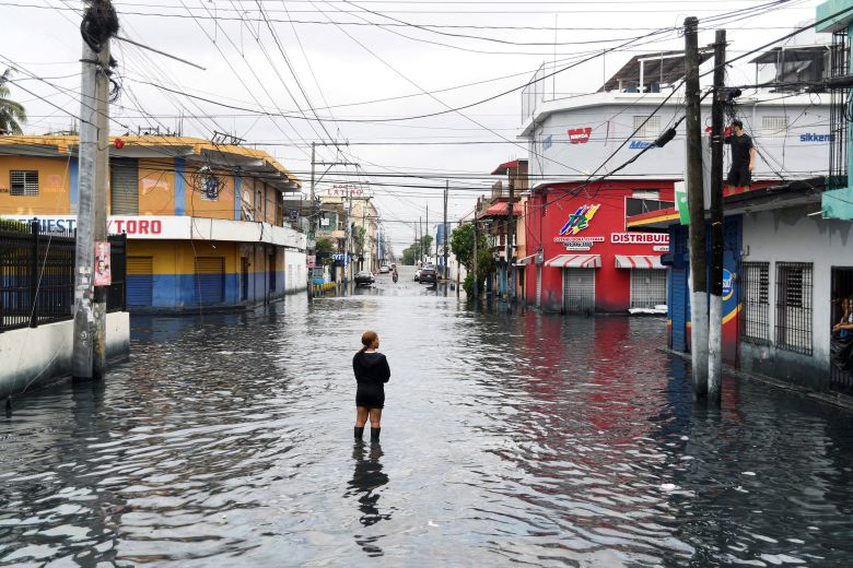
Melissa has already claimed at least four lives in the Caribbean region - three in Haiti and one in the Dominican Republic, with another person missing. The storm caused significant flooding and landslides across Hispaniola, with nearly 200 homes damaged in the Dominican Republic and over 625,000 residents left without clean water.
After devastating Jamaica, Melissa is forecast to continue its destructive path:
Tuesday night: Eastern Cuba, bringing up to 20 inches of rain and storm surge of 6-9 feet
Wednesday: Southeastern Bahamas and Turks and Caicos Islands
Thursday-Friday: Potentially approaching Bermuda
Historical Context of Caribbean Category 5 Hurricanes
While several Category 4 and 5 hurricanes have passed near Jamaica throughout history, none have made direct landfall at such intensity. Only Hurricane Allen (1980) and Hurricane Ivan (2004) have approached within 60 nautical miles of Jamaica as Category 5 storms without making landfall.
The 2025 Atlantic hurricane season now stands as historically significant, featuring three Category 5 hurricanes - the most since the devastating 2005 season that produced Emily, Katrina, Rita, and Wilma. This also marks the fourth consecutive year with at least one Category 5 hurricane in the Atlantic Basin.
Emergency Preparedness and Safety Measures
The National Hurricane Center has issued its strongest warnings, urging residents to "seek shelter now" as conditions rapidly deteriorate. All airports across Jamaica have been closed, with international flights suspended until the storm passes.
Critical infrastructure preparations include:
Power grid reinforcement and emergency generator deployment
Water system protection and backup supply activation
Communication network backup systems
Emergency medical facility preparations
Transportation route clearance and emergency vehicle positioning
Climate Change and Hurricane Intensification
Melissa's rapid intensification from a 70 mph tropical storm to a 160 mph Category 5 hurricane in less than 48 hours exemplifies the concerning trend of rapidly intensifying hurricanes in warming ocean waters. The storm's ability to maintain such extreme intensity while moving slowly through the Caribbean demonstrates the increasing threat posed by major hurricanes to island nations.
As Jamaica braces for this historic storm, the focus remains on life preservation and preparation for what meteorologists are calling a potentially catastrophic natural disaster that could reshape the island's landscape and infrastructure for years to come.
The slow-moving nature of Hurricane Melissa means that impacts will be felt for an extended period, with recovery and damage assessment severely complicated by anticipated landslides, flooding, and blocked transportation routes. This unprecedented storm serves as a stark reminder of the increasing intensity and destructive potential of Atlantic hurricanes in the modern era.